| Ocean Colour |
Level 3 Chl-a, 300m, daily and monthly |
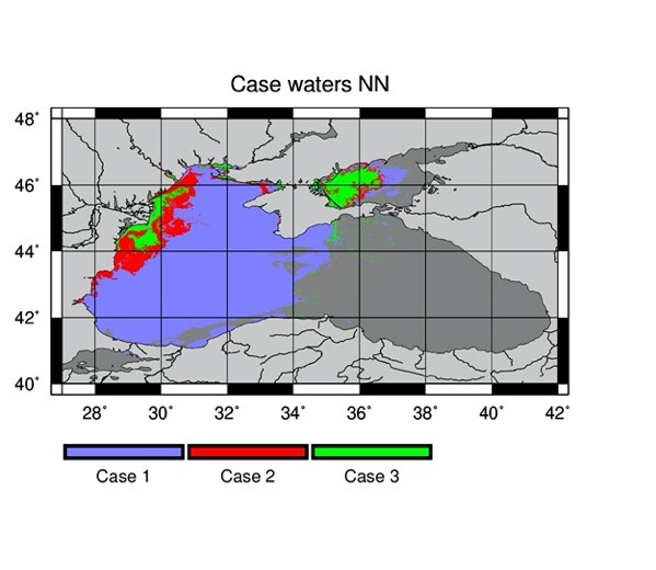
switching algorithm: regional version of teh OC4 algorithm in clear waters and NN-C2RCC algorithm for turbid waters |
2016-04-01 |
2017-12-31 |
Explore & download |
See documentation |
| Ocean Colour |
Level 3 Suspended Particulate Matter, 300m, daily and monthly |
Regional version of the Nechal 2010 algorithm, based on Terrasigna field data |
2016-04-01 |
2017-12-31 |
Explore & download |
See documentation |
| Ocean Colour |
Level 3 Turbidity, 300m, daily and monthly |
Regional version of the Dogliotti et al. (2015) algorithm, based on Terrasigna field data |
2016-04-01 |
2017-12-31 |
Explore & download |
See documentation |
| Ocean Colour |
Level 4 Ocean Colour products Chl-a, 300m, daily |
switching algorithm: regional version of teh OC4 algorithm in clear waters and NN-C2RCC algorithm for turbid waters |
2016-04-01 |
2017-12-31 |
Explore & download |
See documentation |
| Sea Level |
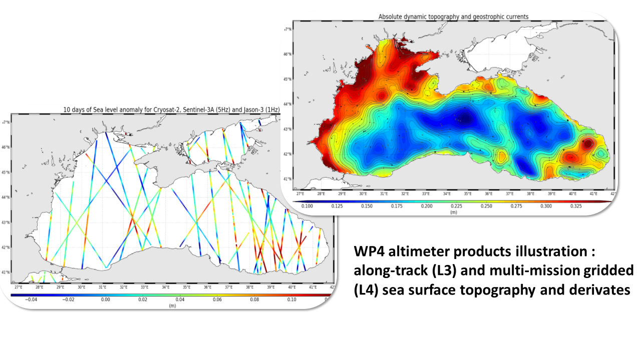
Level-3 Cryosat-2 [2011, 2019] along-track 5Hz product, sea level anomaly, ~1km resolution. |
Along-track Sea Sevel Anomaly (SLA) and derivate/complementary variables. The processing use upstream L2 products with 20Hz sampling and includes :
# a multi-mission cross-calibration processing aiming to reduce global and regional biases observed between measurement from different altimeter missions
# a low-pass filtering aiming to remove short wavelength signal dominated by residual measurement noises.
# a sub-sampling to reach the 5Hz final sampling |
2011-01-01 |
2019-12-31 |
Explore & download |
See documentation |
| Sea Level |
Level-3 Sentinel-3A [mid 2016, 2018] along-track 5Hz product, sea level anomaly, ~1km resolution |
Along-track Sea Sevel Anomaly (SLA) and derivate/complementary variables. The processing use upstream L2 products with 20Hz sampling and includes :
# a multi-mission cross-calibration processing aiming to reduce global and regional biases observed between measurement from different altimeter missions
# a low-pass filtering aiming to remove short wavelength signal dominated by residual measurement noises.
# a sub-sampling to reach the 5Hz final sampling |
2016-07-01 |
2018-12-29 |
Explore & download |
See documentation |
| Sea Level |
Level 4, absolute dynamic topography, multi-mission gridded merged products for a period of 1 year, 0.0625°*0.0625°, daily |
Multimission altimeter gridded product merging SLA field from ESA_BlackSea_EO4SIBS_L4_SLA_2011-2019 and regional Mean Dynamic Topography field from CMEMS (SEALEVEL_BLK_PHY_MDT_L4_STATIC_008_067; Jousset et al, 2022) |
2011-01-01 |
2019-12-31 |
Explore & download |
See documentation |
| Sea Level |
Level 4, sea level anomaly, multi-mission gridded merged products for a period of 1 year, 0.0625°*0.0625°, daily |
Multimission altimeter gridded product merging SLA from different altimeter available.
Sentinel-3A and Cryosat-2 measurements from ESA_BlackSea_EO4SIBS_L3_S3A_SLA_2016-2018 and ESA_BlackSea_EO4SIBS_L3_Cryosat_SLA_2011-2019 products.
Other missions (Jason-3, Jason-2, SARAL/AltiKa, Cryosat-2, HY-2A) from CMEMS 1Hz L3 products (DT-2018 standards; Taburet et al, 2019) |
2011-01-01 |
2019-12-31 |
Explore & download |
See documentation |
| Sea surface current |
Eddy census |
|
2011-01-01 |
2019-12-31 |
Explore & download |
See documentation |
| Sea surface current |
Level 4, geostrophic currents, multi-mission gridded merged products for a period of 1 year, 0.0625°*0.0625°, daily |
Geostrophic current derived from ESA_BlackSea_EO4SIBS_L4_ADT_2011-2019 product using stencil width methodology (Arbic et al, 2012). |
2011-01-01 |
2019-12-31 |
Explore & download |
See documentation |
| Sea Surface Salinity |
Level 2 SMOS , Ascending orbit, 0.25°*0.25°, daily averaged produced daily |
Salinity retrievals from ascending satellite overpasses are averaged in daily maps at 0.25°*0.25° grid. Binning scheme Olmedo et al., 2021a. |
2011-01-01 |
2020-12-31 |
Explore & download |
See documentation |
| Sea Surface Salinity |
Level 2 SMOS , Descending orbit, 0.25°*0.25°, daily averaged produced daily |
Salinity retrievals from ascending satellite overpasses are averaged in daily maps at 0.25°*0.25° grid. Binning scheme Olmedo et al., 2021a. |
2011-01-01 |
2020-12-31 |
Explore & download |
See documentation |
| Sea Surface Salinity |
Level 3 SSS, 0.25°*0.25°, 9-day averaged produced daily |
Salinity retrievals from L2A and L2D over 9 days are used to produce daily values in a 0.25°*0.25° by using the weighted average described in(Olmedo et al., 2021a). The resulting 9-day maps are generated daily. |
2011-01-01 |
2020-12-31 |
Explore & download |
See documentation |
| Sea Surface Salinity |
Level 4 product SSS, 0.05°*0.0505° |
Multifractal fusion applied to L3 SSS. |
2011-01-01 |
2019-12-31 |
Explore & download |
See documentation |